ENVISION SUMMER 2017 UPDATES
We wanted to keep you in the loop about the latest updates to ENvision. We hope these new features will improve the usability and usefulness of our online mapping platform.
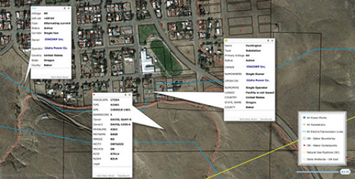
1. Parcel Lookup: Search parcels by owner, address or tax id.
Who owns properties nearby? ENvision shows primary owner names and addresses for millions of properties nationwide regardless of property type. With just a click, you can easily identify the owner of each parcel — both individuals and legal entities. Use ENvision for legal notifications, variances, use permits, licenses and other notification purposes. Our ownership data is updated and in sync with county tax records.
2. FEMA Flood Hazard Zones
The National Flood Hazard Layer (NFHL) is a digital database that contains flood hazard mapping data from FEMA’s National Flood Insurance Program (NFIP). This map data is derived from Flood Insurance Rate Map (FIRM) databases and Letters of Map Revision (LOMRs).
Flood hazards are dynamic and can change frequently because of a variety of factors, including weather patterns, erosion, and new development. FEMA, through the Risk MAP program, works with communities to collect new or updated flood hazard data and periodically updates flood maps to reflect these changes.
3. State Wetlands Layers
The US Fish and Wildlife Service (FWS) is the principal US Federal agency tasked with providing information to the public on the status and trends of our Nation’s wetlands. It includes current geospatially referenced information on the status, extent, characteristics and functions of wetland, riparian, deep-water and related aquatic habitats in priority areas to promote the understanding and conservation of these resources. Available for all 50 US states.
4. New Power Plant Data
New Power Plant data from our robust Transmission and Generation Hub databases. Data includes plant state, NERC region, ISO/RTO, primary fuel and capacity data.
5. MAPSearch Data Maintenance of 2017.
Updates to:
- Over 2,500 Petroleum or Natural Gas facilities
- Over 72,000 miles of pipeline
- Over 1,900 substations across North America